Chapter 4
1700's
Life Situation in Iloilo
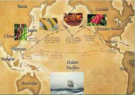
Spanish Imports through Manila-Acapulco
It was not easy for the Spanish to convince the Ilongos to subject to their rule , often meet with resitance. Slowly , as towns were founded , a more advanced knowledge on agriculture were introduced so as to increase the yield
.
Through Manila Acapulco route , Spanish brought crops indigenous in South America to Iloilo such as corn , chilly , cacao ,tomatoes , potato and pineapple through . Soon Philippines exports tobacaoo ,
sugar , corn and coffee.
Life in 1700's was brutish as most part of the world even in Americas . There was no concrete road ,
communication and transportation was facilitated by horses or carabaos through a difficult paths roads that leads to remote towns in Iloilo that was newly established. Since there were no bridges in streams and rivers , boating is the most convenient way travelling from Jaro to Cabatuan using the Salog River ,
Tigum river going to Leon , Jalaur River , from Dumangas to Calinog , passing Pototan , Passi. Northern Villages used boat going to Salog since there was no road in Barotac Viejo and crossing a steep mountain is exhausting. Electricity and light was not yet discovered. All of native homes were made of bambo.
"To these productions the Spaniards have added horses and horned cattle, which have multiplied so much that they are to be found in the mountains without an owner, and where those that want may supply their wants at pleasure. They likewise introduced sheep, geese, grapes, figs, wheat, pepper, coffee, cocoa, sugar, tobacco, and various species of plants, which thrive so well, and produce so much, that the Indian, with all his sloth, acknowledges the utility of cultivating them.
Source: Historical view of Philippine Islands by Zuniga published 1803
Second Wave of foundation of towns
The Spread of Catholic Religion And Western Civilization.
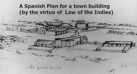
The slow and steady population growth of various barangays in Iloilo prompted the Spanish authorities to convert them into pueblos ( town) to execute its political management effectively. Building a town was under the regulation of " The Law of Indies or Leyes de Indias ( native people) " issued by the Spanish Crown in 1573 .
It is stipulated to design a Pueblo Civil (township) with Parish Priest ,Gobernadorcillo , Municipal Building, plaza Mayor , a cemetery and a market. Often villages names were changed small villages are absorbed into a town . A large swath lands seceded from Jaro such as Catmon , Cabatuan and Maasin. Guimbal and Miag-ao separated from Tigbaun. While Camando and Alimodian seperated from Oton.
Guimbal ( 1703) , Barotac Nuevo ( 1710) Miag-ao ( 1716) ,Leon ( 1730) , Cabatuan ( 1733) , Anilao ( 1734) Barotac Viejo (1750) Igbaras ( 1761) , Banate ( 1763) Janiuay ( 1769) , Tubungan ( 1768) , Santa Barbara , Janiuay (1769) and Maasin ( 1775) among the first group of villages that were given a pueblo (town hood) status. These towns followed the pattern prescribed by the Law of the Indies. However , Churches , cemeteries and municipal buildings were constructed mostly in 1800's . Catholic Religious System became a part of Ilongo lives in a year and have great impact on Ilongo family life especially on rule of marriage custom.
Source: Recopilación de las Leyes de Indias. Titulo Quince. De las Audiencias y Chancillerias Reales de las Indias. Spain 1680.
1703 - Guimbal turned as town, separating from Tigbaun.
For the Spanish , Guimbal was been a sitio of Tigbaun , with its small communities who were under the visita of Tigbaun for years. Spaniards extended its parish there in 1703, and immediately selected its civil leader by the name of Bernardino Ancan. Since 1703, all capitanes were properly recorded up to its present officials. A Spanish Friar by the name of Father Blas Urbina was the founder of the town and was also the one who introduced the Catholic Religion in town , bringing the Spanish civilization. Nuestra Senora de Consolacion was the first patron saint of Guimbal and in 1704, a new patron saint was adopted by the name of St. Nicholas de Tolentino. Guimbal encompasses village of Tubungan as its visita.
1716 - Miag-ao - becomes a Pueblo
Like all its neighboring villages such as Guimbal and Tigbaun, Miag-ao was been an " arrabal of Oton " until 1580 when it was absorved by Suaraga or Suaragan (now San Joaquin) due to its proximity . When Guimbal separated from Tigbaun in 1703 to become a distinct town , Miag-ao was considered as village part of Guimbal . On 1716 , the village of Miag-ao was converted into twon with 13,493 people and 2,974 houses with population congregated in Damilisan , Baybay , Ubus , Igtuba banana plantation , Guibuangan Creek settlement , Kirayan , Naulid River Valley settlement through hard-clay (Dingle) and hard porous area( Gines ).
In 1731 , Through Governor Victorino , there was election in Guimbal , Nicolas Pangkug, whose teniente Mayor of Guimbal, became a Capital serving for three consecutive terms of one year each from 1731-1733 , 1735 and 1739-1740, of Tigbauan until 1752. Muslim pirates wanted to harvest people from Iloilo they realized they hae difficulty in penetrating a fortified city so they turn their attention west of Aninipay , sparsely inhabited and defenseless communities . People of Miag-ao had faced intermittent Muslim Pirates in 1741 looting and burning the Church in Ubus settlement , and burned the Church in 1747 built by Father Fernando Camporendondo . In May 7 , 1754, 21 Muslim raiders landed in Baybay Norte , Jose Echavarria with his troops drove the muslim off. They later returned and landed at Damilisan but were again repulsed under the leadership of Francisco Arburo, whose forces were supported financially by Don Baltazar Javier, one of the richest men in the poblacion.
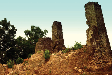
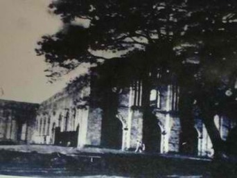
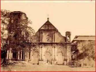
Construction of Miag-ao Fortress Church
1786 - Spanish Augustinian missionaries, under Fray Francisco Gonzales, parish priest of the town and Spanish gobernadorcillo Domingo Libo-on. It took a decade to build the edifice in Tacas . The fortress design, composed of massive stone walls at 1.5-meters thick and strong four-meter-thick buttresses. The belfries served as a watchtower. Concrete slabs of “ Igang” (sandstone), making up the original church, were hauled from Sitio Tubog in nearby San Joaquin town and from the mountains of Igbaras. The sandstones were bonded by lime mortar. A native from Igbaras named Matias is said to be the foreman who supervised the early construction of the church until he was replaced by Aquino, a native from Alimodian, according to the church's historical records. It was completed in 1797 and served as not only a Church but also a fortress against Muslim raiders.
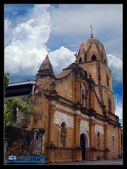
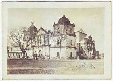
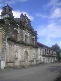
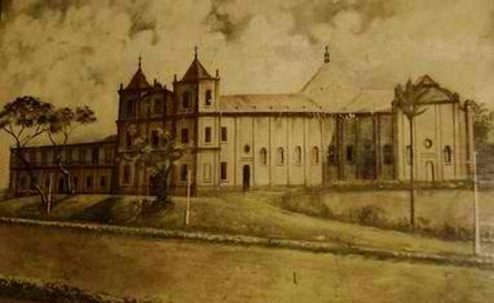
Jaro Church
1726 - Jaro Church, across the street from the plaza, was first built before 1726 by Fr. Bernardino Alisen. It was relocated to it current site by Fr. Bernardino Alisen and completed from 1742 to 1744 by Fr. Juan Aguado. Belfry was built by the Spaniards, and while the structure was essentially a religious shrine, it
also served as a military watchtower closely watching ships that is visiting Iloilo. Jaro Parish kept records of all baptismal marriage and burial records. However, in 1787, the Jaro Belfry was heavily damaged by a powerful earthquake. It was not until 1883, several decades later, that any attempt at reconstructing the place began, through the efforts of Father Jesse Alvarez.
In 1731 , Through Governor Victorino , there was election in Guimbal , Nicolas Pangkug, whose teniente Mayor of Guimbal, became a Capital serving for three consecutive terms of one year each from 1731-1733 , 1735 and 1739-1740, of Tigbauan until 1752. Muslim pirates wanted to harvest people from Iloilo they realized they hae difficulty in penetrating a fortified city so they turn their attention west of Aninipay , sparsely inhabited and defenseless communities . People of Miag-ao had faced intermittent Muslim Pirates in 1741 looting and burning the Church in Ubus settlement , and burned the Church in 1747 built by Father Fernando Camporendondo . In May 7 , 1754, 21 Muslim raiders landed in Baybay Norte , Jose Echavarria with his troops drove the muslim off. They later returned and landed at Damilisan but were again repulsed under the leadership of Francisco Arburo, whose forces were supported financially by Don Baltazar Javier, one of the richest men in the poblacion.
Construction of Miag-ao Fortress Church
1786 - Spanish Augustinian missionaries, under Fray Francisco Gonzales, parish priest of the town and Spanish gobernadorcillo Domingo Libo-on. It took a decade to build the edifice in Tacas . The fortress design, composed of massive stone walls at 1.5-meters thick and strong four-meter-thick buttresses. The belfries served as a watchtower. Concrete slabs of “ Igang” (sandstone), making up the original church, were hauled from Sitio Tubog in nearby San Joaquin town and from the mountains of Igbaras. The sandstones were bonded by lime mortar. A native from Igbaras named Matias is said to be the foreman who supervised the early construction of the church until he was replaced by Aquino, a native from Alimodian, according to the church's historical records. It was completed in 1797 and served as not only a Church but also a fortress against Muslim raiders.
Jaro Church
1726 - Jaro Church, across the street from the plaza, was first built before 1726 by Fr. Bernardino Alisen. It was relocated to it current site by Fr. Bernardino Alisen and completed from 1742 to 1744 by Fr. Juan Aguado. Belfry was built by the Spaniards, and while the structure was essentially a religious shrine, it
also served as a military watchtower closely watching ships that is visiting Iloilo. Jaro Parish kept records of all baptismal marriage and burial records. However, in 1787, the Jaro Belfry was heavily damaged by a powerful earthquake. It was not until 1883, several decades later, that any attempt at reconstructing the place began, through the efforts of Father Jesse Alvarez.
1716 - Capiz , Aklan and Romblon seperated from Iloilo
Capiz Province separated from jurisdiction of Iloilo as distinct polito-military commandencia with it’s down Military and Political Governor. At the same time , Ibajay , Makato , Banga , Batan and Romblon was annexed to Capiz.
Letter of Bishop Sebastian Foronda, O.S.A. dated May 11, 1714 in Capiz.
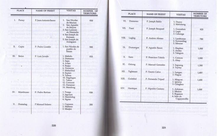
There are 7 Spanish Towns composed of their respective several large villages
Passi - includes the ancient settlement of Guayahon , Lupa and Cabonga
Laglag - includes the ancient settlement of Lambunao , Sumanding and Sibucao
Dumangas - includes ancient villages of Hapitan , Anilao and Talaugis
Xaro - includes large ancient hamlets of Catmon ( Cabatuan Lucena , Maasin ) and Abay
Octong - includes Iguang ang Taytay
Tigbaun - includes Langao and Hagua
The newly establish Spanish town of Guimbal covers villages of Miag-ao and Igbaras
1730 - Barotac Viejo parish was Established
Barotac Viejo had its first priest in the person on Fray Gregorio Montaner OSA, assigned there from 1830 to 1856 and seperated as visita of Ajuy.
1730 - a Village Camando becomes a Pueblo
1730 -The Municipality of Leon was formerly known as Camando which was founded in the year 1730 with Mr. Bernabe Buncag as the Gobernadorcillo
1733 - Cabatuan becomes a Pueblo
1733- Cabatuan was officially organized as town of Iloilo upon the installation of Rev. Fr. Antonio Lopez as its first priest and Capitan Tono as its first “gobernadorcillo.” Parish Priest of Cabatuan visits a small village of Maasin to conduct sacramental baptism and marriage. It covers salog river from Talanghaun ( viewing plateu) , Guibuangan ( river-mouth) , Pamul-ogan , Tabucan ( river-crossing) , a swath of Canipaan ( Janipaan) . A Church was erected in the Plateu Area ,
As testified by a Jesuit writer, there were identified ministries in early towns of Iloilo and surprisingly , several towns that has not been founded yet were not included as they were only a visita status .
“In the province of Otón, in the same island, the convents and ministries of Magao, Antique, Bugason,
Tigbauan, Cabutuan, Laglag, Pasi, Anilao, Dumangas, the island of Guimarás, Jaro, Otón,
and Guimbal, with several missions of wild people[cimarrones] in the mountains, apostates and their children, in which the care and zeal of the same fathers has been exercised since the year 1731, and in
which the gain and profit of many souls is not wanting.”
Source: Religious Condition of the Islands, by Juan J. Delgado, S.J. (written in 1751–54)
1734 - Anilao was founded
Negros Occidental no longer part of Iloilo Province.
1734 - Negros Occidental became a province apart from Iloilo tax payments in kind continued going directly to Panay until 1734. In that year, Spain transformed all of Negros into a single administrative and revenue collection district with its capital, orcabecera , at Ilog
1734 - Negros Occidental became a province apart from Iloilo tax payments in kind continued going directly to Panay until 1734. In that year, Spain transformed all of Negros into a single administrative and revenue collection district with its capital, orcabecera , at Ilog
Spanish Parish of Iloilo as of 1734
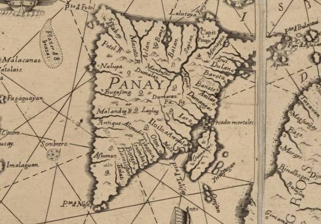
Ancient Towns or its visitas explicitly mentioned are Iloilo and Arevalo ( Please note text "Iloilo" appeared ,terminus post quem suggest earliest possible usage not more than 1734 its date of publication in Manila
There are 15 established Spanish towns ( Pueblo Civil) such as:
Jaro , Arevalo , Molo , Jaro ( stretching to current Lapaz and Leganes covers visitas of Catmon which streched far to Cabatuan and Maasin) , Guimbal , Tigbaun , Oton , Dumangas , Anilao , Banate , Barotac , Ajuy Dulano , Laglag , Pase , Alimodian.
There are 3 identified ancient settlement
Tiolas (absorbed as barangay of San Joaquin)
Damilisan (absorbed as barangay of Miagao)
Bongol (absorbed as barangay of Guimbal)
There's a chasm between Jaro and Dumangas . It is understandable Zaraga and Leganes is not yet founded .
Dumangas covers the present Barotac Nuevo.
Leon , Santa Barbara and Cabatuan may not be present due to lack of Church and they are connected to Jaro Parish althrough they are already founded in times of publication
The unnamed places in far North are Estancia , Sara , Conception , San Dionisio , Batad , Balasan and Carles
There are other existing places in the West like Janiuay , Mina , Lambunao and Calinog but may be unreached by the Spanish Friars.
In Negros , primitive settlement of Ilog , Himamaylan , Binalbagan , Bago and Magsungay.
Source: 1734 - Map of The Philippines by Jesuit Fray Murillo Velarde published in Manila " Carta Hydrographica y Chorographica de las Yslas Filipinas Dedicada al Rey Nuestro Señor por el Mariscal " with Panacot Shoal, British map adopted it in 1794 by Robert Carr , claim by China today.
1755 - Alimodian was founded as Spanish Town
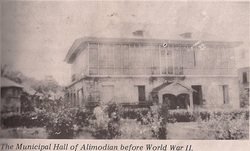
People desire to build a Spanish Town
1753 - It is not so easy and indeed a sacrifice for people of Alimodian to travel to Ogtong to attend their civil and religious duties. Leaders of Buhay and Bagumbayan under Agustin Magtanong meet to discuss matters such as building of an ermita, tribunal or municipio (municipal hall) and an buluthuan (school). The leaders did not came into agreement after several " puisay" or arguments.
Prophetic Location " Cabudian Creek"
1754- Strong men of Alimodian able to undertake difficult and long journey of logs from Island of Inampulangan in Guimaras , transported it to coast of Ogtong and carabaos carried it . It passed territory of Buhay , the Lanot (rope) did not break and people were dismayed. As the carabao crossed the creek at the bank of Cabudian Creek , the pitik " roped' was snapped prophetically telling them " Poblacion" location. it neither pleased bagumbayan and buhay folks. After months of dedicated voluntary work, a town, complete with the requirements set up by the Spanish Law of the Indies , Spanish town came into being.
1755 - The building or " Muncipio" and " Iglicia " or church was ready. The populace petitioned for the installation of a teniente absoluto for the visita of Alimodian as well as parish priest. A priest was sent under Fray Vicente. Finally , Alimodian officially separated from Ogtong on August 20, 1756.
1757 - With the help of M.R. Fray Jacinto del Puno, Vicar General of the Agustinian Fathers, they appealed to the provincial government of Governor Manuel Salazar de los Monteros to appoint a captain or gobernadorcillo for the visita so it would be recognized as a full-fledged municipality. The governor arrived in Ogtong on January 8, 1757 to choose the future gobernadorcillo. Governor arrived , under endorsement of principales ( Local Princes ) and Fray Francisco Calsetas , Agustin Magtanong was chosen as first gobernatorcillo.
1760 - Santa Barbara becomes a pueblo
After a century since the discovery of first Spanish Explorers, the population was under the Spanish government of Jaro. The population grew to several thousands . Township was necessary in order for Spanish Government to have facility to manage Catmon settlement from Cadagmayan , Cabugao . Catmon was established as an independent parish and no longer a part of Jaro Parish. The village was turned into a “pueblo” It was given patron saint, Santa Barbara and the town was named after her. Its total population at the time was 15,094, covering an villages of Zarraga, New Lucena and a part of Leganes and Pavia.
1761 - Igbaras becomes a Pueblo
1761 - Fr. Juan Aguado founded the town site of
Igbaras in 1752, named after the word “baras” which is very abundant in the locality. After 9 years in 1761 , Don Diego Tamooc was installed as Gobernadorcillo to
head the new pueblo . The old church was constructed in 1784, followed by the convent in 1795 under Fr. Ignacio Marcos. These structures were also washed away by the big floods but the remains are still visible today. With sufficient money to construct prominent edifices , Gobernadorcillo Don Pedro Sexto, built the “Casa Real” around 1799 at Calle de San Augustin. a
municipal street completely inundated by the floods.
1763 - Banate was founded
1766: Pueblo of Passi was founded
Martin Saligumba in 1766 when the Spanish administration recognized the existence of Passi as a pueblo. He became the first Captain Basal Actaul of the town
1768 - Tubungan becomes a town
1768 - The town of Tubungan was formally founded in 1768 through the efforts of Tan Mangon in barrio Tin-an that now forms part of the present town site. The people who settled there came mostly from Nahapay, Guimbal and from neighboring towns of Leon, Igbaras and Tigbuan.
In 1769, it was an “arrabal” (a political unit bigger than a barrio) of Guimbal and Agustin Mambuti was appointed the first Teniente to represent Tubungan in the Municipal council of Guimbal.After several years, in 1803, Tubungan became a municipality with Fernando Paguntalan as its first Capitan, the highest office in the municipality that time. However, bandit raids placed .the town under danger, and led to the incorporation of Tubungan to Guimbal from 1806 to 1820.
In 1769, it was an “arrabal” (a political unit bigger than a barrio) of Guimbal and Agustin Mambuti was appointed the first Teniente to represent Tubungan in the Municipal council of Guimbal.After several years, in 1803, Tubungan became a municipality with Fernando Paguntalan as its first Capitan, the highest office in the municipality that time. However, bandit raids placed .the town under danger, and led to the incorporation of Tubungan to Guimbal from 1806 to 1820.
Unifying 4 ancient settlements
4 Ancient Malay Settlement
The nine families from Talaugis, Dumangas journeyed along the Suagi River , The first settlers were led by families of Gumok, Hutikot, Ugamot and Pagdakton and settled in Matag-ub some in Yabun , Danao and Ubian . Datu Biruk heads Ilawod, Kanhe, Datu of Danaw, Lubang Banwa, Datu of Yabon,
Batakun, Datu of Kiput. A small Parish was founded in 1578 as a "visita of Dumangas" . Priest from Dumangas
have to visit the far flung community to conduct Mass , or Baptism or Marriage. The 4 settlement multiplied slowly .
Spanish conquered 4 ancient settlements - Foundating of Visita of Yabun
In 1738 , a " visita of Yabun" was founded when their leader Datu Buhawi , accepted Spanish Rulers. Different datus surrendered with the exception of Datu Dimag-tol of Ubian who escaped with his followers to the mountains and later became the leader of the bandits. The Spanish governing Power who was called Teniente Absulto- the following persons ruled with their respective tenures: Kabatak - 1738; Balitok - 1739; Panayaw - 1740; Labawon - 1741; Likawan - 1742; Marcelo (lowlander) - 1743; and Batakun -1744.
Visita of Danaw and the Tinientes
The government center in 1745 move to Danaw and the first Catholic mass held in a provisional shack called “Ermita”.Cruz - 1745; Sagrado - 1746; Dumara-ug - 1747; Puti - 1748; Kapnaw - 1749; Rambana - 1750; Umilig - 1751; Tungkayas - 1752; Katuha - 1743; Lumaway - 1754; Alinsanan - 1755; Tanyu - 1756; Buingan - 1757
Laoud changed into Matag-ub and became Visita
1759, it was moved again to Matag-ub becomes dependent in 1752. The settlements in Matag-ub grew to 27. It was center of political, and government where people recognized the Spanish Rule.
1764 : Territorial Town Boundery
Spanish Governor General isued an order that sought to establish the bounderies of the towns. The order also provided for the establihsment of the territorial area of township of Matag-ub which comprised the settlements founded by the settlers from tala-ugis.
" The boundery line between Cabatuan and Matag-ub is the Hanipaan-creek running through and following its course up to its source thence to the source of Gines creek, thence running straight to the ridge of Kawis. The boundery between Maasin and Matag-ub begins from Kawis thence to Burak , thence to Kalumbuyan , thence to Garang , thence to the source of Tigbawan creek , thence to the peak of Tamayo Mountain , where on a very large boulder markings in the form of crossing line and letter M are engraved and on the north side of this monument is referred to Matag-ub , and all lands lying north of said marker as indicated by the cross lines belongs to Matag-ub. The letter M on the south side refers to Maasin. The boundery between Matag-ub and Laglag ( Duenas) starts from peak of Mount Singit running between Mount Iday Hanggod and Mount Inday Kayot, thence to the upper ridge of the source of Abangay creek , thence following the course of this creek until Tina to the place where the bounderies of Laglag , Dingle and Matag-ub converge."
" The boundery line between Cabatuan and Matag-ub is the Hanipaan-creek running through and following its course up to its source thence to the source of Gines creek, thence running straight to the ridge of Kawis. The boundery between Maasin and Matag-ub begins from Kawis thence to Burak , thence to Kalumbuyan , thence to Garang , thence to the source of Tigbawan creek , thence to the peak of Tamayo Mountain , where on a very large boulder markings in the form of crossing line and letter M are engraved and on the north side of this monument is referred to Matag-ub , and all lands lying north of said marker as indicated by the cross lines belongs to Matag-ub. The letter M on the south side refers to Maasin. The boundery between Matag-ub and Laglag ( Duenas) starts from peak of Mount Singit running between Mount Iday Hanggod and Mount Inday Kayot, thence to the upper ridge of the source of Abangay creek , thence following the course of this creek until Tina to the place where the bounderies of Laglag , Dingle and Matag-ub converge."
1769- Janiuay was born

1769- the Spanish Governor Francisco Bayot de Ocampo recommended to the “Principalia” the transfer to strengthen in their administration to the present location . A community was named Janiuay subjugating Danao , Yabun and Matag-ub . A Catholic Church was built of sandstone, lime stone and layered bricks and was completed in February 1770. Its
belfry used to carry three magnificent bells, the largest weighing close to a
town.
belfry used to carry three magnificent bells, the largest weighing close to a
town.
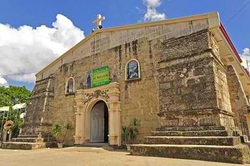
1775 - Maasin becomes a Pueblo
1775 - With growing population of " principalia of Maasin" under the pueblo of Cabatuan. A new Spanish Priest is needed and gobernadorcillo to overseer the edict of " Obras Pias" of the locals . A village of Maasin was elevated into a pueblo ( town ) . Don Agustin Garcia was appointed as its first Capitan to oversee the collection of taxes and governing of the people. A beautiful church and Cemetery soon was about to be constructed. It covers Bagacay Settlement , Bucao ( Naslo) , Tawog , Igbanday , Abay , Ese , Camanse and Talindak.
(Iglesia del Pueblo de Maasin, Iloilo (1877)
(Iglesia del Pueblo de Maasin, Iloilo (1877)
